
What is GeoAI?
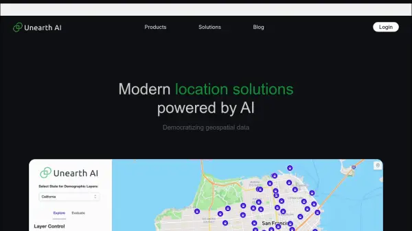
GeoAI leverages the synergy between Artificial Intelligence and geospatial engineering to transform how industries utilize spatial information. By employing advanced AI techniques like machine learning, deep learning, and knowledge graphs, GeoAI processes and analyzes diverse geospatial data sources, including satellite imagery, maps, and laser scanning data. This integration allows for the identification of patterns, trends, and correlations that are often missed by traditional methods, leading to more informed and strategic decisions.
The platform offers a suite of technologies designed for applications such as monitoring construction projects, predicting urban growth, facilitating urban planning, monitoring vegetation health, and optimizing asset performance. GeoAI aims to provide businesses, governments, and organizations with innovative tools and AI-driven geospatial insights, enabling them to streamline operations, achieve sustainable outcomes, and gain a competitive edge in a complex world. Their team comprises certified engineers, surveyors, and programmers, collaborating with university researchers to stay current with technological advancements.
Features
- Geospatial Data Analysis: Utilizes AI (machine learning, deep learning) to process and analyze satellite imagery, maps, and laser scanning data.
- Construction Site Monitoring: Provides tools for monitoring the progress and status of construction projects.
- Vegetation Monitoring: Enables analysis of vegetation health and changes using spatial data.
- Asset Management Optimization: Leverages AI for improved management and performance of assets.
- Digital Twin Creation: Develops immersive digital representations of physical environments or assets.
- Knowledge Graph Integration: Uses knowledge graphs to structure and analyze geospatial information.
- Urban Planning Support: Offers insights for predicting urban growth and planning city development.
Use Cases
- Monitoring construction projects for progress and compliance.
- Predicting urban sprawl and planning city infrastructure.
- Assessing vegetation health for agriculture or environmental management.
- Optimizing the performance and maintenance of infrastructure assets.
- Creating virtual replicas (digital twins) of cities or facilities for simulation and analysis.
- Analyzing spatial patterns for resource management.
- Leveraging location intelligence for business decision-making.
Related Queries
Helpful for people in the following professions
GeoAI Uptime Monitor
Average Uptime
0%
Average Response Time
0 ms