 ReddRadar
Top AI tools for Urban Planner
-
 Permitify Design with Confidence. Submit with Certainty.
Permitify offers AI-powered site-specific code research and plan review for architects and engineers, helping to catch compliance issues early and streamline the permit submission process.
- Paid
- From 99$
-
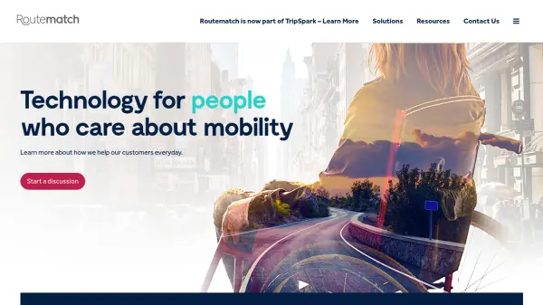 Routematch Technology for people who care about mobility
Routematch provides AI-powered transit solutions that connect transit agencies with riders through automated fare collection, fixed route optimization, demand response services, and mobility management.
- Contact for Pricing
-
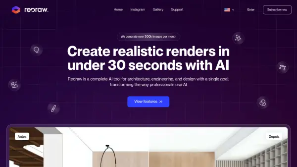 Redraw Generate Realistic Renders in Under 30 Seconds with AI
Redraw is an AI-powered tool for architects, engineers, and designers to create realistic renders, generate design ideas, and enhance images quickly.
- Paid
- From 13$
-
 Architecture Helper Explore and Imagine Architecture Through AI Analysis and Generation
Architecture Helper is an AI-powered platform that analyzes real-world buildings and generates new architectural designs. For $5/month, users can analyze buildings, generate custom designs, and explore different architectural styles.
- Paid
- From 5$
-
 Pataa The New Language of Address!
Pataa is an advanced addressing solution that provides short, unique digital address codes to simplify long and complex addresses, enhancing delivery efficiency and customer experience.
- Free Trial
-
 Geospatial Cloud Serv Advanced geospatial data serving and microservices for comprehensive GIS solutions
Geospatial Cloud Serv provides a powerful self-hosted solution for advanced geospatial data serving, microservices, and APIs, compatible with various GIS platforms and mobile applications.
- Pay Once
-
 Donkey Republic Rent a bike 24/7 with flexible, app-based mobility solutions
Donkey Republic provides an AI-driven bike-sharing platform that allows users to rent bicycles on-demand in multiple European cities through a mobile app, offering flexible pricing options including pay-per-ride, memberships, and day passes.
- Freemium
-
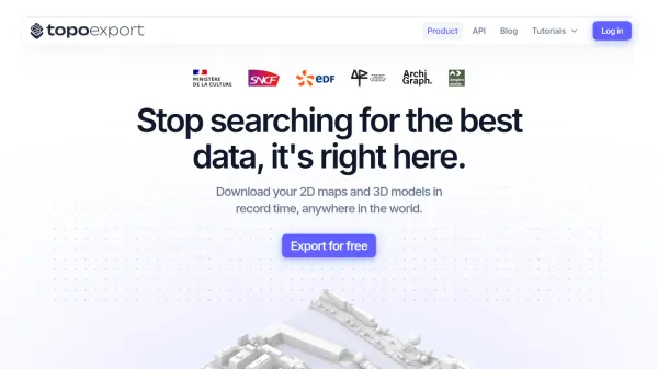 TopoExport Download 2D maps and 3D models in record time, anywhere in the world.
TopoExport is an AI-powered platform that enables professionals to quickly export customizable 2D topographic maps and 3D terrain models in various vector formats for architecture, urban planning, and design projects.
- Freemium
-
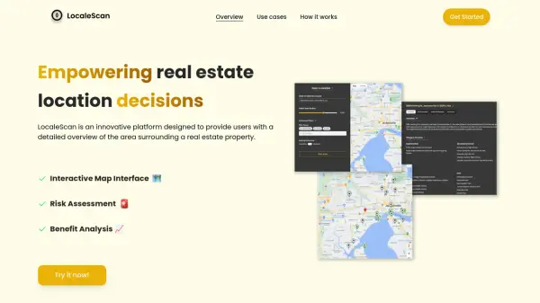 LocaleScan Empowering Real Estate Location Decisions
LocaleScan provides a detailed overview of areas surrounding real estate properties, utilizing AI to assess risks and benefits for informed decision-making.
- Free
-
 MangoMap Powerful, Affordable Online GIS Mapping for Professionals
MangoMap is an easy-to-use, cost-effective online GIS mapping platform designed for professionals who need robust mapping capabilities without the complexity or high licensing fees of traditional solutions.
- Paid
- From 79$
-
 INRIX Leading Transportation Analytics Solutions Powered by AI
INRIX provides AI-driven transportation analytics solutions that leverage big data to improve mobility, enhance safety, and optimize business operations across various industries.
- Contact for Pricing
-
 Augurisk Instant Disaster and Societal Risk Assessment
Augurisk provides instant and free disaster and societal risk reports for homes, cities, or neighborhoods in the United States.
- Freemium
- From 90$
-
 ShadySide Dodge the sun, enjoy the ride!
ShadySide is an AI-powered tool that analyzes your route to recommend the shadiest seating options for public transit, ensuring comfortable travel by avoiding direct sunlight.
- Other
-
 Wayfindr Empowering Independent Indoor Navigation for the Vision Impaired
Wayfindr is an award-winning non-profit creating accessible audio navigation standards to help blind and partially sighted individuals navigate indoor environments independently.
- Free
-
 DreamLADU Design Your Accessory Dwelling Unit in Seconds
DreamLADU is an AI-powered platform that enables users to quickly design and customize their ideal Accessory Dwelling Unit (ADU), offering both creative inspiration and detailed personalization features.
- Freemium
- From 20$
-
 Bird Electric Bikes and Scooters For Cities
Bird provides micro-electric mobility solutions including electric bikes and scooters to reduce traffic and promote cleaner air in urban environments.
- Contact for Pricing
-
 Cadmapper Get instant CAD files for any location on earth
Cadmapper transforms data from public sources like OpenStreetMap, NASA, and USGS into neatly organized CAD files, saving hours of routine drawing for designers, architects, and illustrators.
- Freemium
-
 OpalAI Transforming spatial data into actionable insights with intelligent analysis
OpalAI is an advanced AI platform that converts spatial, visual, and point cloud data into detailed 3D models, BIM (Building Information Models), and actionable insights for various industries.
- Usage Based
- From 1$
-
 Carmen Cloud Advanced Cloud-Based License Plate Recognition for Global Vehicle Monitoring
Carmen Cloud delivers powerful, AI-driven license plate recognition, vehicle make and model recognition, and automated detection across 200+ countries through a flexible, cloud-based platform.
- Freemium
- From 35$
-
 boardyonboard.com The Original Boardscooter for All-Terrain Gliding
Boardy is a premium boardscooter featuring a flexible wooden frame for smooth, surf-like rides across various terrains, designed with sustainability and durability in mind.
- Paid
-
 caliper.com Mapping the Future with Cutting-Edge Software Solutions
Caliper provides comprehensive mapping, GIS, and transportation software solutions for businesses and government agencies to analyze data, optimize operations, and plan strategically.
- Other
-
 Easy Render High-quality 3D architectural rendering services for architects, designers, and developers.
Easy Render connects you with a global network of top 3D artists for stunning 3D architectural renderings, including interior, exterior, aerial, and VR renderings. Post a job, hire the best artist, collaborate online, and pay securely.
- Contact for Pricing
-
 Sound Event Detector (SED) AI-powered sound analysis for real-time threat detection and security enhancement.
SED (Sound Event Detector) is an AI-powered solution that uses sound analysis to detect dangerous situations like gunshots, screams, aggression, and drones, providing real-time alerts to enhance security and save lives.
- Contact for Pricing
-
 ARU SKYNET On-Demand Aerial Intelligence for Smarter Decisions
ARU SKYNET is an AI-powered drone data management platform that enables organizations to upload, analyze, and collaborate on aerial intelligence with 20x higher resolution for enhanced decision-making.
- Contact for Pricing
-
 Placekey Solve address matching problems for places
Placekey provides a universal identifier for any physical place, simplifying data sharing and solving address matching challenges across organizations using a unique 'What@Where' format.
- Freemium
- From 200$
-
 Visualizee.ai From Concepts to Realistic Visualizations in 10 Seconds
Visualizee.ai is a leading AI rendering tool designed to transform sketches, images, 3D models, or text prompts into stunning realistic renders within seconds, saving time and resources for architects and designers.
- Freemium
- From 9$
- API
-
 Mapit GIS Mobile GIS for asset collection, GPS surveys, and field data management
Mapit GIS is a professional mobile GIS platform for iOS and Android that enables offline-first data collection, GPS surveys, and field data management with support for GeoPackage, multiple export formats, and sub-metre GNSS accuracy.
- Other
-
 xyzt.ai Turn your IoT data into actionable insights
xyzt.ai is a powerful platform that combines spatial and time series analysis to visualize and analyze spatio-temporal data from any source, regardless of size. It specializes in IoT, maritime, and mobility data analytics with GenAI-powered insights.
- Contact for Pricing
-
 Zumper Find your fresh start with millions of rental listings
Zumper is an AI-powered rental platform that helps users discover and apply for over 1 million houses and apartments for rent across the U.S. and Canada, offering comprehensive listings, useful resources, and verified information for a secure rental experience.
- Other
-
 Happy Cities Creating happier, healthier, more inclusive communities through urban planning and design
Happy Cities is an urban planning, design, and research consultancy that works with governments, developers, and non-profits worldwide to design neighborhoods, public spaces, and housing that nurture wellbeing for all community members.
- Contact for Pricing
-
 PolicyMap Comprehensive Mapping & Data Analytics For Smarter Decision-Making
PolicyMap is a cloud-based platform offering extensive data mapping, visualization, and analytics tools, empowering users to make impactful, data-driven decisions across sectors such as government, non-profit, finance, academic, and healthcare.
- Contact for Pricing
-
 Susterra Advanced Analytics for Public Finance
Susterra provides advanced analytics platforms using AI and ML for public finance stakeholders, aiming to enhance urban development and grow the Municipal Bond Market.
- Paid
- From 999$
-
 Roadcount Monitor and record traffic on your street, 24/7, automatically on your phone
Roadcount utilizes your phone to automatically monitor, count, and record street traffic 24/7, providing evidenced data including speed estimates.
- Contact for Pricing
-
 Every Door The best OpenStreetMap editor for POIs and entrances.
Every Door is an open-source OpenStreetMap editor designed for mapping points of interest, entrances, and micro-mapping features with offline capabilities and AI-assisted data validation.
- Free
-
 Spectator Live Satellite Monitoring and Centralized Data Access
Spectator is an AI-powered platform that provides seamless access to Earth observation satellite data from programs like Copernicus Sentinels and USGS/NASA Landsat, offering daily fresh satellite images, high-resolution commercial imagery, and flexible tools for tracking satellite passes and scheduling imaging.
- Freemium
-
 AIBOT The High-Tech & High Performance aiEVTOL
AIBOT is developing AI-defined, high-performance electric Vertical Take-Off and Landing (aiEVTOL) aircraft to revolutionize regional mobility, offering a safe, zero-emission, and cost-efficient solution.
- Contact for Pricing
-
 Hayden AI Revolutionizing Problem-Solving with AI
Hayden AI provides an AI-powered mobile perception platform that utilizes deep learning for various applications, including automated traffic enforcement and data-driven insights for cities.
- Contact for Pricing
-
 EasyPZ The easiest way to find restrooms in Berlin
EasyPZ is a free mobile app that helps users quickly locate nearby restrooms in Berlin, designed to be more reliable and faster than Google Maps.
- Free
-
 HydroCAD The competitive edge in hydrology & hydraulics software since 1986
HydroCAD is a Computer Aided Design tool for modeling stormwater runoff, offering a wide range of hydrology and hydraulics capabilities to speed up engineering workflows ten-fold.
- Other
-
 CSV2GEO Batch Geocoding, Reverse Geocoding, and Interactive Map Creation
CSV2GEO is an online tool for converting addresses to geographic coordinates (latitude/longitude) and vice-versa in bulk. It also enables users to create and publish interactive maps from their data.
- Freemium
-
 Humans.ai Making AI Work for Humans
Humans.ai is an AI and blockchain ecosystem offering personalized AI tools designed to deliver transparent, equitable, and ethical AI solutions. It pioneers a decentralized approach to data validation, ensuring fair and unbiased AI systems.
- Contact for Pricing
-
 Archezy Lay the Foundation for Successful Data and Project Management for AEC Professionals
Archezy is a comprehensive project and data management platform designed specifically for architects, interior designers, urban planners, and AEC professionals to streamline collaboration, enhance efficiency, and deliver exceptional project outcomes.
- Freemium
- From 30$
-
 Atlas AI The AI Platform for Geospatial Insights
Atlas AI is a geospatial AI platform providing hyperlocal socio-demographic indicators and forecasting tools, empowering data scientists with location intelligence.
- Contact for Pricing
-
 LTU Tech Advanced Visual Recognition and Image Analysis Solutions
LTU Tech leverages patented algorithms to deliver advanced image recognition, visual search, and risk management solutions across industries, enhancing operational efficiency and asset protection.
- Other
-
 Modelur SketchUp Supercharged for Urban Design
Modelur is an AI-powered urban design plugin for SketchUp that enables architects and planners to explore design possibilities with real-time feedback on key metrics through seamless Excel integration.
- Freemium
- From 74$
-
 Trafi Multi-modal journey planning platform for sustainable urban mobility
Trafi provides a comprehensive B2G multi-modal journey planning technology platform that integrates public transport and micro-mobility services to help cities reduce congestion and emissions through sustainable travel solutions.
- Contact for Pricing
-
 Snaptrude Program to proposals at lightning speed with data-backed design concepts
Snaptrude is a web-based 3D modeling and space planning tool that enables architects and designers to create and validate design concepts quickly, complete with AI-powered rendering capabilities.
- Free Trial
-
 One One Six Apartments Luxury apartment living in Carmel, IN with modern designs and superb amenities
One One Six Apartments offers luxury apartment living in Carmel, Indiana, featuring modern floor plans, premium amenities, and a convenient location near local attractions.
- Contact for Pricing
-
 Regrid Comprehensive parcel data with boundaries, buildings, addresses, and geographic enrichments for all your location decisions.
Regrid provides comprehensive parcel data for the U.S. and Canada, including boundaries, ownership, addresses, and geographic insights, accessible via app, data store, API, and enterprise solutions.
- Freemium
-
 Rekor Revolutionary Roadway Intelligence Powered by AI
Rekor is an advanced AI-powered roadway intelligence platform that collects, connects, and analyzes mobility data to provide comprehensive traffic management, vehicle recognition, and public safety solutions.
- Contact for Pricing
Featured Tools
Join Our Newsletter
Stay updated with the latest AI tools, news, and offers by subscribing to our weekly newsletter.
Didn't find tool you were looking for?