ReddRadar


What is Parknav?
Parknav leverages advanced artificial intelligence, big data analysis, and patented data science technologies to deliver highly accurate parking information. It processes a vast array of real-time and historical data from sources including automobile sensors, cell phone towers, weather patterns, satellite imagery, traffic data, and proprietary inputs to achieve industry-leading precision in its predictions.
The platform offers a comprehensive suite of parking solutions, including real-time predictions for on-street parking availability, detailed information on parking restrictions (specifying where, what type, and when they apply), and turn-by-turn voice-guided navigation to guide users directly to available on-street or off-street parking spots. This service covers over 1000 cities across North America and Europe, catering to individual drivers, businesses, and smart city initiatives.
Features
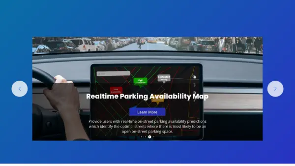
- Real-time Parking Availability Map: Predicts and displays streets with high probability of open on-street parking.
- Parking Restrictions Information: Provides detailed data on parking rules, times, and locations.
- Turn-By-Turn Parking Navigation: Offers voice-guided routes directly to available on-street and off-street parking.
- AI and Data Science Innovation: Employs AI and big data for high precision parking predictions (80% benchmark).
- Extensive City Coverage: Operates in over 1000 cities across North America and Europe.
- Navigation SDK: Allows integration of parking navigation into third-party applications.
- Parking Analytics: Provides insights based on parking data for cities and businesses.
Use Cases
- Finding available street parking in real-time.
- Checking parking rules and time restrictions before leaving the car.
- Navigating efficiently to the nearest predicted open parking space.
- Integrating real-time parking data into vehicle navigation systems.
- Developing smart city solutions for traffic and parking management.
- Providing parking information services for mobility apps.
- Analyzing parking patterns for urban planning and real estate development.
FAQs
-
What kind of data does Parknav use for its predictions?
Parknav processes real-time and historical data from diverse sources like automobile sensors, cell phone towers, weather sensors, car-sharing fleets, mapping providers, satellite imagery, traffic patterns, real estate data, city information, and proprietary sources. -
How accurate are Parknav's parking predictions?
Parknav utilizes advanced AI and data science, aiming for an industry benchmark of 80% precision in predicting parking availability for every city it covers. -
How many cities does Parknav cover?
Parknav provides parking data and services for over 1000 cities located in North America and Europe. -
Does Parknav offer navigation to parking spots?
Yes, Parknav offers real-time, turn-by-turn voice-guided navigation directing users to predicted open on-street and available off-street parking spaces through its mobile app and Navigation SDK. -
Is Parknav suitable for businesses and developers?
Yes, Parknav offers solutions for various industries including Automotive, Mobility, Real Estate, and Cities, providing APIs and SDKs for integration.